
![]()
Ski and Snowboard ride GPS tracker. Tracks your rides downhill and lifts up-hill. Stores GPS coordinates, altitude, speed, weather conditions as well as your body acceleration metrics during the ride. Allow to share rides over the social networks. Allow to have your favorite winter resort maps offline (no internet connection required to see a map with trails and lifts). Present your records in “hall of fame”.
Features:
* Track ski and snowboard ride while in your pocket
* Uses iphone GPS/Glonass sensor as well as accelerometer
* Have more than three thousand resorts info
* Track speed, coordinates, altitude, accelerations and more
* History per day and per ride
* Re-play ride on a map
* Show local weather and forecast for next days
* Share individual ride and day info via messages, emails and social networks (Facebook, Twitter)
* Saves ride info into local Health Kit (workouts, calories, winter sport activity)
* Generate an animated video of a ride on a 3D map
* Localized to English, Russian, German, Italian, French, Spanish, Portuguese, Chinese and Japanese
How to use
- Before you go to your favorite winter sports resort you may want to download offline map while your phone is within Wifi range. Typical resort map is about 50-100Mb.
- To do that – on main tracker interface (one with the map) position and scale the map to your current location (assuming you are in ski/snowboard resort) and tap “Offline Map” button. It will load offline map for the whole visible area (make sure you zoomed out to include whole resort*)
- Now you ARE in your favorite winter sports resort (ski, snowboard, any other winter sports equipment)
- The tap on Tracker on/off button – it will turn red when ON.
- Put your phone into pocket and enjoy the winter!
- When done for a day – tap and hold on Tracker on/off button to switch tracking off
Interfaces
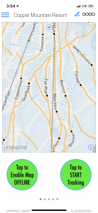
Tracker
Tracker is a main interface. You will turn Tracker ON by taping left round button – it will turn red. To turn it off – tap and hold for few seconds. You will see a progress bar going around the button. Once complete the circle, the tracker will be off.
You also can include a visible map area into offline mode (app will download an offline version of this map for use in no-internet areas).
-
- Tracker off
-

- Tracker on
-

- Turn tracker off by holding
Other main interfaces
You can swipe left and ride (not over map, though) to flip via three main interfaces: Tracker, Today’s Activity and Weather.
-

- Today Events
-

- Weather
Settings
Settings allow you to set units and sensitivity of app towards downhill and uphill activities. Your weight is used with calories calculation and can be entered manually or (if you enabled Health Kit info sharing) via Health Kit import.
-

- Settings
History
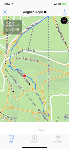
History of your rides is shown by days, grouped by months. Each day will present summary activity as well as a list of events. You can drill down to each event or swipe them to left to enable Delete button if you want to remove unnecessary ones.
Ride details include an interactive map (you slide control to move your marker from start to finish of a ride). App will show the relative time (from start) and current speed. Lift ride will only include a map.
-

- History
-

- Day Info and Events
-
- Ride map
-

- Ride Details
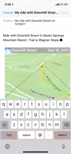
Sharing
You can share one particular ride or entire day of activities. Sharing can be done via iMessage, Email, Twitter or Facebook.
-

- Ride Sharing
-
- Ride sharing via Email
Animated video on 3D Map
Application can generate an animated video of a ride as a line coming through the trains on a 3D map. Such video can be locally stored or shared via standard iOS tools.
In-App Store
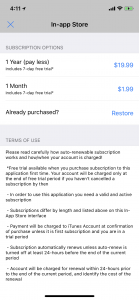
In order to use the app you will need to subscribe via In-App store. Subscriptions are auto-renewable and can be managed via iTunes. For the first subscription you will get a free 7 days and if you haven’t cancelled it before 7 days are gone, will be charged a subscription fee. You can cancel subscription at any moment – there is a link on In-App Store interface to go to iTune to do so.
-
- Not yet licensed
-

- View for licensed app